
113th Field Artillery Photos
THEN: Dr. Van Heely
NOW: Tim Ypelaar, Kerkrade, Holland

Kerkrade Remembers!!
![]()
Original January 1944 map in sections of Kerkrade!! Scale: 1:10,000 Any help matching photos found below to locations on map appreciated!!
 No.1
No.1
 No.2
No.2
 No.3
No.3 No.4
No.4
 No.5
No.5 No.6
No.6
From "Workhorse of the Western Front"

Description of action of 120th history book:


Map of Kerkrade area...1943.

 THEN
THEN
 NOW "Church of Kaalheide"
 THEN
THEN
 NOW "Dragonteeth of the Siegfried Line"
 THEN
THEN
 NOW "Snipers being brought into Kaalheide from Kerkrade. The only tram
line was the Kaalheidersteenweg. Tram is gone and bicyle path replaces
it."
NOW "Snipers being brought into Kaalheide from Kerkrade. The only tram
line was the Kaalheidersteenweg. Tram is gone and bicyle path replaces
it."
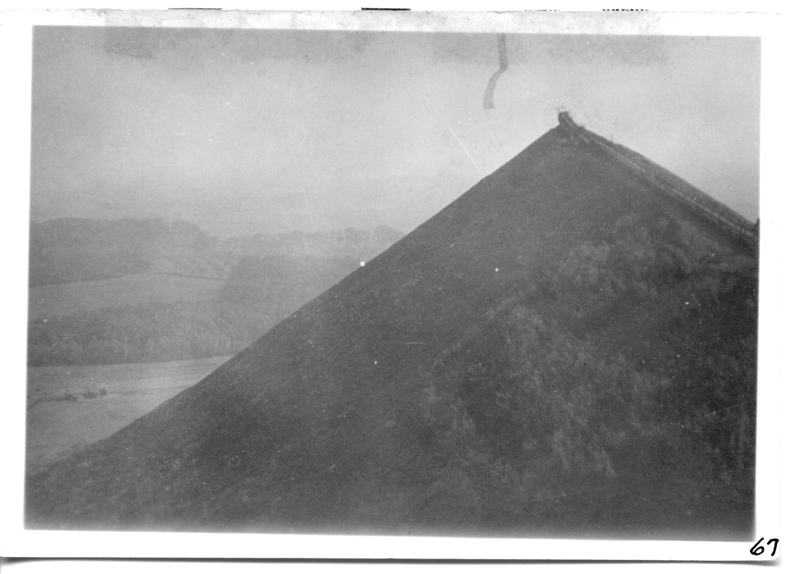 THEN
THEN
 NOW "Slagpile has changed alot in 62 years but it is the same hill.
It is now called the 'Skiberg' used by Snowworld (a indoor ski/snowboard
company).
NOW "Slagpile has changed alot in 62 years but it is the same hill.
It is now called the 'Skiberg' used by Snowworld (a indoor ski/snowboard
company).
 THEN
THEN
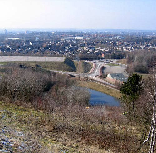 NOW "Taken on top of the slagpile. Mining installation in 'THEN'
photo is gone. Only the lake remains."
NOW "Taken on top of the slagpile. Mining installation in 'THEN'
photo is gone. Only the lake remains."
 THEN
THEN
 NOW "Holland-German border outside Kerkrade, Holland.
"Nieuwstraat/Neustrasse" it has a Dutch and German
name because the left side in Dutch and the right side is German. There was
nothing to recognize on the photo anymore, but my grandpa and some family of him
knew exactly were it was."
NOW "Holland-German border outside Kerkrade, Holland.
"Nieuwstraat/Neustrasse" it has a Dutch and German
name because the left side in Dutch and the right side is German. There was
nothing to recognize on the photo anymore, but my grandpa and some family of him
knew exactly were it was."
 THEN
THEN
 NOW "The evacuation of Kerkrade, people walking on the Wienweg. The road
has changed but the farm is almost the same!"
NOW "The evacuation of Kerkrade, people walking on the Wienweg. The road
has changed but the farm is almost the same!"
The following "THEN" photos are from the book "Kerkrade in de Tweede Weredoorlog" (Kerkrade in WWII)
 THEN
THEN
 NOW
NOW
 THEN
THEN
 NOW
NOW
"An American Sherman tank driving through the Industriestraat in Kerkrade. The original photo has been taken on 17 September 1944. The building on the right used to be a farm I guess, and is now a pet store. Note the hook on the triangular roof, it is still there now."
 THEN
THEN
 NOW
NOW
"An American Sherman tank driving through the Industriestraat in Kerkrade. The original photo has been taken on 17 September 1944. The house with the Dutch flag hanging out, was a butcher, but doesn't exist anymore. Some local people helped me finding the exact place. The building on the background, is the same building as on the next photo."
 THEN
THEN
 NOW
NOW
"On 7 November 1944, Charles Dimmock's P-47 Thunderbolt got shot down by friendly fire. American troops must have mistaken him for a German fighter and opened fire. US files say he must have been killed by the bullets, because if he had been alive while he was crashing he would have tried to save the aircraft. He crashed in the Bockstraat, destroying 2 houses 38 and 40. That are the 2nd and 3rd building from the right on the new photo. A six year old girl from the Meijs family, sadly got killed as well. Charles Dimmock, the pilot, is buried at the Margraten American Military Cemetery in plot F, row 8, grave 20."
 THEN
THEN
 NOW
NOW
 THEN
THEN
 NOW
NOW
___________________________________________________________________________________________________________
 THEN
THEN
 NOW
NOW
___________________________________________________________________________________________________________________________
 THEN
THEN
 NOW
NOW

Dear sir,
Many thanks for your site. It remembers me a lot of
my childhood.Your request in helping some picture to
match them with the map I easily can help you with
pictures Evacuation Kerkrade 2 #1 & #2 (Bleijerheidestraat
25) and the location on map KerkradeMap6. The
location is depicted by the circle on the map (cut
out from centre of KerkradeMap6). The picture was
taken from the Bleijerheidestraat, the street left,
round the corner is the Vroenstraat. Again thanks,
kind regards and success with your further
investigations ,
Mart van den Boomen
MANY THANKS Mart!! 3/16/2009
_____________________________________________________________________________________________________________________________
 THEN
THEN
 NOW
NOW
____________________________________________________________________________________________________________________________
 Additional Photo